Chicago is divided into 77 official community areas, numbered 1 (Rogers Park) to 77 (Edgewater). They are the City’s fixed units for planning and data, and almost every Chicago neighborhood name people use day to day — River North, Wicker Park, Pilsen, Andersonville — sits inside one of them. This page lists all 77, grouped into the nine sides of the city, with each area’s number, size and a short description written for apartment hunters.
The descriptions cover what a renter needs to place an area: where it is, what it borders, the neighborhoods inside it, the kind of buildings on its streets, and the train lines that serve it. They describe places, not people, and they do not rank one area against another. Where an area contains buildings in this directory, its entry links straight to them.
Chicago Neighborhoods and Community Areas at a Glance
Short answer: Chicago has 77 official community areas and a much larger, informal set of Chicago neighborhoods. The community areas are the City’s fixed units for planning and statistics. The neighborhood names people actually say — River North, Wicker Park, Pilsen, Andersonville — sit inside them.
- How many community areas: 77, numbered 1 (Rogers Park) to 77 (Edgewater), unchanged since 1980.
- How many Chicago neighborhoods: there is no official count. Residents use well over a hundred names, and their edges are informal.
- Which one is official: community areas have fixed boundaries. Neighborhood names do not, they often overlap, and they far outnumber the 77.
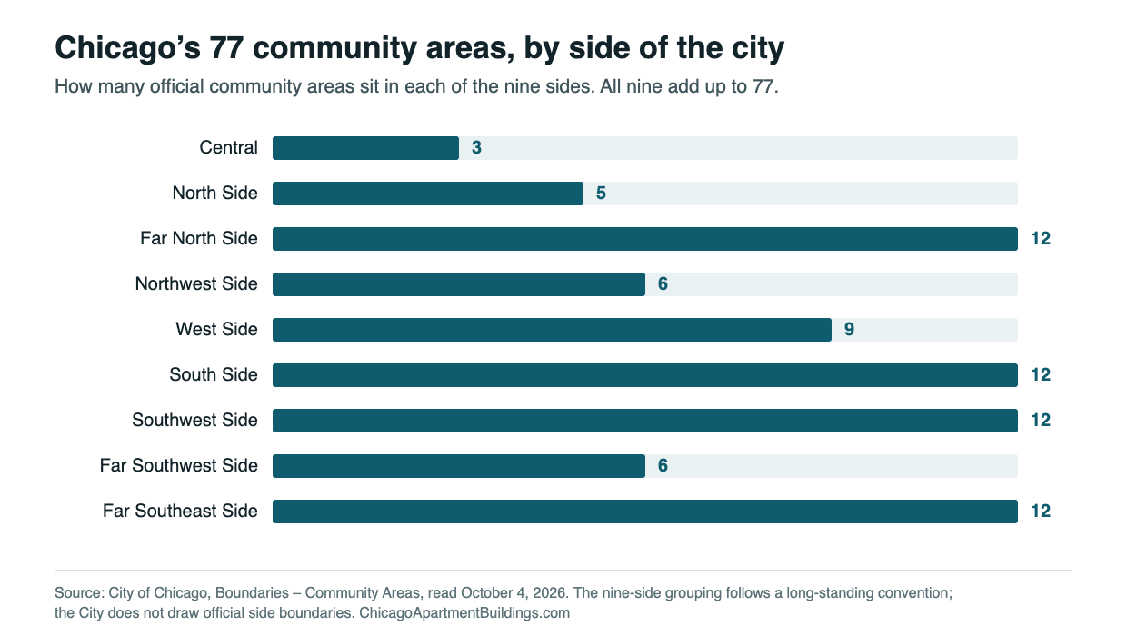
- How this page is organised: all 77 areas, grouped into the nine sides of the city, from Central to Far Southeast Side.
- Total size: about 231 square miles. O’Hare is the largest at about 13.3 square miles; Oakland and Burnside are the smallest at about 0.6 square miles each.
- Where this directory’s buildings are: mostly in twelve community areas, concentrated downtown, along the North Side lakefront and in Hyde Park.
Each of the 77 entries below gives the area’s official number, its size, the neighborhoods inside it, the kinds of buildings on its streets and the train lines that serve it. The entries describe places, not people, and they do not rank one area against another. If you are not sure which part of the city to look in, start with the nine side-of-city groups; if you already have an area in mind, jump straight to it from the table of all 77.
Chicago Community Areas: Quick Facts
- Number of community areas: 77, unchanged since 1980, when O’Hare (76) and Edgewater (77) completed the set.
- Total area: about 231 square miles across all 77, as measured from the City’s boundary file, which includes some water such as Lake Calumet.
- Largest: O’Hare, about 13.3 square miles, most of it the airport.
- Smallest: Oakland and Burnside, each about 0.6 square miles.
- Community area vs. neighborhood: community areas have fixed official boundaries; neighborhood names are informal, often overlap, and far outnumber the 77.
- Where this directory’s buildings are: mostly in twelve community areas, concentrated downtown, along the North Side lakefront and in Hyde Park. See the breakdown.
All 77 Chicago Community Areas
Sorted by the City’s official number. Select a name to jump to its description. Sizes are rounded to a tenth of a square mile. The last column links to this directory’s neighborhood pages, each listing the apartment buildings we cover there; a dash means we don’t list buildings in that area yet.
| No. | Community area | Side | Size (sq mi) | Our neighborhood pages |
|---|---|---|---|---|
| 1 | Rogers Park | Far North Side | 1.8 | — |
| 2 | West Ridge | Far North Side | 3.5 | — |
| 3 | Uptown | Far North Side | 2.3 | Uptown / Edgewater |
| 4 | Lincoln Square | Far North Side | 2.6 | — |
| 5 | North Center | North Side | 2.0 | — |
| 6 | Lake View | North Side | 3.1 | Lakeview |
| 7 | Lincoln Park | North Side | 3.2 | Lincoln Park · Gold Coast / Old Town |
| 8 | Near North Side | Central | 2.8 | River North · Gold Coast / Old Town · Streeterville / Lakeshore East · Near North Side |
| 9 | Edison Park | Far North Side | 1.1 | — |
| 10 | Norwood Park | Far North Side | 4.4 | — |
| 11 | Jefferson Park | Far North Side | 2.3 | — |
| 12 | Forest Glen | Far North Side | 3.2 | — |
| 13 | North Park | Far North Side | 2.5 | — |
| 14 | Albany Park | Far North Side | 1.9 | — |
| 15 | Portage Park | Northwest Side | 4.0 | — |
| 16 | Irving Park | Northwest Side | 3.2 | — |
| 17 | Dunning | Northwest Side | 3.7 | — |
| 18 | Montclare | Northwest Side | 1.0 | — |
| 19 | Belmont Cragin | Northwest Side | 3.9 | — |
| 20 | Hermosa | Northwest Side | 1.2 | — |
| 21 | Avondale | North Side | 2.0 | — |
| 22 | Logan Square | North Side | 3.6 | Wicker Park / Bucktown / Logan Square |
| 23 | Humboldt Park | West Side | 3.6 | — |
| 24 | West Town | West Side | 4.6 | Wicker Park / Bucktown / Logan Square |
| 25 | Austin | West Side | 7.1 | — |
| 26 | West Garfield Park | West Side | 1.3 | — |
| 27 | East Garfield Park | West Side | 1.9 | — |
| 28 | Near West Side | West Side | 5.7 | West Loop / Fulton Market · Near West Side |
| 29 | North Lawndale | West Side | 3.2 | — |
| 30 | South Lawndale | West Side | 4.6 | — |
| 31 | Lower West Side | West Side | 2.9 | — |
| 32 | Loop | Central | 1.7 | The Loop · Streeterville / Lakeshore East · South Loop |
| 33 | Near South Side | Central | 1.8 | South Loop |
| 34 | Armour Square | South Side | 1.0 | — |
| 35 | Douglas | South Side | 1.7 | — |
| 36 | Oakland | South Side | 0.6 | — |
| 37 | Fuller Park | South Side | 0.7 | — |
| 38 | Grand Boulevard | South Side | 1.7 | — |
| 39 | Kenwood | South Side | 1.0 | — |
| 40 | Washington Park | South Side | 1.5 | — |
| 41 | Hyde Park | South Side | 1.6 | Hyde Park |
| 42 | Woodlawn | South Side | 2.1 | Hyde Park |
| 43 | South Shore | South Side | 2.9 | — |
| 44 | Chatham | Far Southeast Side | 3.0 | — |
| 45 | Avalon Park | Far Southeast Side | 1.3 | — |
| 46 | South Chicago | Far Southeast Side | 3.3 | — |
| 47 | Burnside | Far Southeast Side | 0.6 | — |
| 48 | Calumet Heights | Far Southeast Side | 1.8 | — |
| 49 | Roseland | Far Southeast Side | 4.8 | — |
| 50 | Pullman | Far Southeast Side | 2.1 | — |
| 51 | South Deering | Far Southeast Side | 10.9 | — |
| 52 | East Side | Far Southeast Side | 3.0 | — |
| 53 | West Pullman | Far Southeast Side | 3.6 | — |
| 54 | Riverdale | Far Southeast Side | 3.5 | — |
| 55 | Hegewisch | Far Southeast Side | 5.2 | — |
| 56 | Garfield Ridge | Southwest Side | 4.2 | — |
| 57 | Archer Heights | Southwest Side | 2.0 | — |
| 58 | Brighton Park | Southwest Side | 2.7 | — |
| 59 | McKinley Park | Southwest Side | 1.4 | — |
| 60 | Bridgeport | South Side | 2.1 | — |
| 61 | New City | Southwest Side | 4.8 | — |
| 62 | West Elsdon | Southwest Side | 1.2 | — |
| 63 | Gage Park | Southwest Side | 2.2 | — |
| 64 | Clearing | Southwest Side | 2.6 | — |
| 65 | West Lawn | Southwest Side | 3.0 | — |
| 66 | Chicago Lawn | Southwest Side | 3.5 | — |
| 67 | West Englewood | Southwest Side | 3.2 | — |
| 68 | Englewood | Southwest Side | 3.1 | — |
| 69 | Greater Grand Crossing | South Side | 3.5 | — |
| 70 | Ashburn | Far Southwest Side | 4.9 | — |
| 71 | Auburn Gresham | Far Southwest Side | 3.8 | — |
| 72 | Beverly | Far Southwest Side | 3.2 | — |
| 73 | Washington Heights | Far Southwest Side | 2.9 | — |
| 74 | Mount Greenwood | Far Southwest Side | 2.7 | — |
| 75 | Morgan Park | Far Southwest Side | 3.3 | — |
| 76 | O’Hare | Far North Side | 13.3 | — |
| 77 | Edgewater | Far North Side | 1.7 | Uptown / Edgewater |
Central Community Areas (3)
Downtown and the blocks wrapped around it. The Central community areas hold most of the city’s high-rise apartment towers, nearly every ‘L’ line, and the commuter rail terminals. Almost every building in this directory sits here or on the North Side lakefront.
Loop
Community area 32 · Central · about 1.7 sq mi · Buildings in this directory: The Loop · Streeterville / Lakeshore East · South Loop
The Loop is Chicago’s downtown community area, bounded by the Chicago River on the north and west, Roosevelt Road on the south and Lake Michigan on the east. Beyond the office core, it includes residential pockets such as Lakeshore East near the mouth of the river, Printer’s Row along Dearborn Street and the northern part of Dearborn Park. Grant Park, Millennium Park and Maggie Daley Park line the lakefront side. The Brown, Green, Orange, Pink and Purple lines run on the elevated Loop tracks, and the Red and Blue lines run in subways beneath State and Dearborn. Metra serves Millennium Station, Van Buren Street and LaSalle Street Station. Most housing is in high-rise rental and condo towers, along with older office and loft buildings converted to apartments.
Near North Side
Community area 8 · Central · about 2.8 sq mi · Buildings in this directory: River North · Gold Coast / Old Town · Streeterville / Lakeshore East · Near North Side
The Near North Side sits directly north of the Loop, bounded by the Chicago River on the south and west, Lake Michigan on the east and North Avenue on the north. It holds several distinct districts: Streeterville, the Gold Coast, River North, the Magnificent Mile, Goose Island and the southern part of Old Town. High-rise and mid-rise buildings dominate, from postwar towers to recent construction, alongside greystones and row houses on Gold Coast side streets and converted lofts in River North. The Red Line stops at Grand, Chicago and Clark/Division, and the Brown and Purple lines stop at Merchandise Mart, Chicago and Sedgwick. Navy Pier, the Water Tower, Northwestern Memorial Hospital, the Newberry Library, the Museum of Contemporary Art and Oak Street Beach are all here.
Near South Side
Community area 33 · Central · about 1.8 sq mi · Buildings in this directory: South Loop
The Near South Side begins at Roosevelt Road and extends south to 26th Street, between the Chicago River and Clark Street on the west and Lake Michigan on the east. It covers much of what people call the South Loop, including the Prairie Avenue District, Central Station, Motor Row along Michigan Avenue, and the southern part of Dearborn Park. Its lakefront holds the Museum Campus with the Field Museum, Shedd Aquarium and Adler Planetarium, plus Soldier Field, Northerly Island and McCormick Place. The Red, Green and Orange lines stop at Roosevelt on the northern edge, and the Green Line also stops at Cermak-McCormick Place. Metra Electric trains stop at 18th Street and McCormick Place. Housing includes high-rise towers, mid-rise buildings, loft conversions and townhomes.
North Side Community Areas (5)
The North Side areas run from North Avenue up to roughly Montrose, between the lake and the river’s North Branch. Housing shifts from lakefront high-rises in the east to two-flats, three-flats and courtyard buildings farther west, with the Red, Brown and Blue lines carrying most commuters.
Avondale
Community area 21 · North Side · about 2.0 sq mi
Avondale is a community area between Addison Street to the north and Diversey Avenue to the south, with the North Branch of the Chicago River on the east and Pulaski Road and the Milwaukee District North rail line on the west. The Kennedy Expressway runs diagonally through it, and the Blue Line stops at Belmont and at Addison. Milwaukee Avenue is the main commercial street, and the twin-towered St. Hyacinth Basilica is a prominent landmark. Housing consists largely of two-flats, three-flats and frame worker cottages, along with some loft conversions of former industrial buildings, including the old Dad’s Root Beer plant. Elston Avenue and the riverfront still hold light industry and warehouse buildings. Avondale Park, Brands Park and several smaller playlots make up its park space.
Lake View
Community area 6 · North Side · about 3.1 sq mi · Buildings in this directory: Lakeview
Lake View covers the lakefront from Diversey Parkway north to Irving Park Road, reaching Montrose Avenue near the shore, with Ravenswood Avenue on its western side. It contains several well-known neighborhoods, including Lakeview East, Wrigleyville, Northalsted, the Southport Corridor and Graceland West. Wrigley Field stands at Clark and Addison. Transit is dense: the Red Line stops at Addison, Sheridan and Belmont; the Brown Line serves Belmont, Southport, Paulina and Wellington; and Purple Line express trains add rush-hour service at Belmont and Wellington. Lake Shore Drive and the lakefront parks, including Belmont Harbor, line the east side. Housing ranges from high-rises near the lake to vintage courtyard buildings, three-flats, greystones and newer condo buildings inland. Broadway, Halsted, Clark, Southport and Belmont are the main commercial streets.
Lincoln Park
Community area 7 · North Side · about 3.2 sq mi · Buildings in this directory: Lincoln Park · Gold Coast / Old Town
Lincoln Park runs from North Avenue up to Diversey Parkway, between Lake Michigan and the North Branch of the Chicago River. Its smaller neighborhoods include the Old Town Triangle, Mid-North, Sheffield, Wrightwood Neighbors, Park West and the RANCH Triangle. The lakefront park that shares its name holds the Lincoln Park Zoo, the Conservatory, North Pond, the Chicago History Museum and the Peggy Notebaert Nature Museum. DePaul University’s main campus is centered near Fullerton Avenue. The Red and Brown lines meet at Fullerton, the Brown Line also stops at Armitage and Diversey, and Purple Line express trains serve all three at rush hours. Housing includes lakefront high-rises, nineteenth-century row houses and greystones, brick walk-ups and some newer construction. Armitage, Halsted, Lincoln, Clark and the Clybourn corridor are the main shopping streets.
Logan Square
Community area 22 · North Side · about 3.6 sq mi · Buildings in this directory: Wicker Park / Bucktown / Logan Square
Logan Square stretches from Diversey Parkway south to the Bloomingdale Trail, known as The 606, with the North Branch of the Chicago River on the east and the Milwaukee District North rail line on the west. Its neighborhoods include Bucktown, Palmer Square, Belmont Gardens, Kosciuszko Park and the area around the square itself, where the Illinois Centennial Monument stands. A landmark district of wide boulevards, Logan, Kedzie, Palmer and Humboldt, runs through the area. The Blue Line stops at Logan Square, California and Western, and the Kennedy Expressway crosses the eastern section. Housing includes greystones, two-flats and three-flats, single-family homes on the boulevards and side streets, courtyard buildings and newer mid-rise construction near the train. Milwaukee Avenue, Damen Avenue and the streets around the square hold most of the businesses.
North Center
Community area 5 · North Side · about 2.0 sq mi
North Center occupies the area between Diversey Parkway and Montrose Avenue, bounded by Ravenswood Avenue on the east and the North Branch of the Chicago River on the west. Roscoe Village, St. Ben’s and the area around the Northcenter Town Square at Lincoln, Damen and Irving Park are the names most residents use. The Brown Line stops at Irving Park and Addison, with Montrose station on the northern border. Lincoln Avenue, Damen Avenue and Roscoe Street carry most of the shops and restaurants. The housing stock is largely two-flats, greystones, frame houses and newer single-family and condo construction, with fewer large apartment buildings than areas closer to the lake. Lane Tech College Prep occupies a large campus on Western Avenue, and Hamlin Park and the riverside Clark Park offer recreation.
Far North Side Community Areas (12)
The largest group, stretching from the Uptown and Edgewater lakefront to O’Hare Airport. Lakefront areas have dense apartment stock along the Red Line; the areas to the northwest are mostly single-family streets served by Metra and the Blue Line.
Albany Park
Community area 14 · Far North Side · about 1.9 sq mi
Albany Park is a community area bounded on the south by Montrose Avenue, with the North Branch of the Chicago River along its eastern and northern sides. Ravenswood Manor, Mayfair and North Mayfair are neighborhoods within it. The Brown Line ends here, with stops at Francisco, Kedzie and the Kimball terminal near Lawrence Avenue. The Edens Expressway runs past the western side, and Metra’s Mayfair station is close by. Lawrence Avenue and Kedzie Avenue are the main commercial streets. Housing is relatively dense, with many courtyard buildings, two-flats and three-flats, plus bungalows and single-family homes in Ravenswood Manor and Mayfair. Parks include River Park along the river, Ronan Park, Eugene Field Park and Gompers Park.
Edgewater
Community area 77 · Far North Side · about 1.7 sq mi · Buildings in this directory: Uptown / Edgewater
Edgewater sits on the lakefront, running from Foster Avenue north to Devon Avenue and from Ravenswood Avenue east to Lake Michigan. Its western portion includes Andersonville, centered on Clark Street’s shops and restaurants, along with Lakewood-Balmoral, Edgewater Glen and Magnolia Glen; the eastern lakefront section is Edgewater Beach. Housing varies widely, with high-rise condominium and rental towers along Sheridan Road, vintage courtyard buildings and three-flats on interior streets, and single-family homes in the historic districts. The Red Line stops at Berwyn, Bryn Mawr, Thorndale and Granville along Broadway. Lake Shore Drive ends at Hollywood Avenue and becomes Sheridan Road here. Foster Beach and Osterman Beach line the shore, and Loyola University’s campus adjoins the area to the north.
Edison Park
Community area 9 · Far North Side · about 1.1 sq mi
Edison Park is a small community area at the far northwest corner of the city, with the suburbs of Park Ridge and Niles on two sides and Norwood Park to the south. It was annexed to Chicago in 1910 and grew up around its commuter rail stop. Metra’s Union Pacific Northwest Line stops at Edison Park station, and the blocks of Northwest Highway and Olmsted Avenue near the station form the main business district, with a concentration of restaurants. Housing is mostly single-family homes on tree-lined residential streets, and larger apartment buildings are uncommon. Many of the north-south streets here have names that begin with the letter O. Brooks Park and Olympia Park are the main parks. No ‘L’ station is located within the area.
Forest Glen
Community area 12 · Far North Side · about 3.2 sq mi
Forest Glen is a community area made up of three neighborhoods: Edgebrook, Sauganash and Forest Glen. The North Branch of the Chicago River and its forest preserves run along the western and northern side, with LaBagh Woods, the Edgebrook Golf Course and the Billy Caldwell Golf Course among the open lands. The Edens Expressway forms part of the eastern edge. Metra’s Milwaukee District North Line stops at Forest Glen and Edgebrook stations, and there is no ‘L’ service inside the area. Housing is overwhelmingly single-family, including older homes on winding streets in Old Edgebrook, period-revival brick houses in Sauganash, and some newer construction, so rental apartment buildings are scarce. Edgebrook’s small commercial district centers on Devon Avenue near the train station.
Jefferson Park
Community area 11 · Far North Side · about 2.3 sq mi
Jefferson Park is a community area organized around the Jefferson Park Transit Center at Milwaukee and Lawrence avenues, where the Blue Line, Metra’s Union Pacific Northwest Line and numerous CTA and Pace bus routes meet. The Kennedy Expressway runs through it, and the Edens Expressway forms part of its eastern boundary. Gladstone Park, a neighborhood in the northern part of the area, has its own Metra stop. Milwaukee Avenue is the main commercial street and is home to the Copernicus Center, a performance venue in the former Gateway Theatre. Housing is mostly brick bungalows and two-flats, with low-rise and mid-rise apartment and condo buildings along Milwaukee Avenue and near the transit center. Jefferson Memorial Park, on land that was once a farm, is the area’s main green space.
Lincoln Square
Community area 4 · Far North Side · about 2.6 sq mi
Lincoln Square lies between Montrose Avenue to the south and Bryn Mawr and Peterson avenues to the north, with Ravenswood Avenue on the east and the North Branch of the Chicago River on the west. Neighborhoods inside it include Ravenswood, Bowmanville, Budlong Woods and Ravenswood Gardens. Lincoln Avenue is the central shopping street, anchored near Western Avenue by a pedestrian plaza and the Old Town School of Folk Music. The Brown Line serves Damen, Western and Rockwell, and Metra’s Union Pacific North Line stops at Ravenswood station on the eastern edge. Housing is mostly two-flats, brick three-flats, courtyard buildings and bungalows. Welles Park, Winnemac Park and River Park provide open space, and Rosehill Cemetery, the Sulzer Regional Library and Swedish Hospital are local landmarks.
North Park
Community area 13 · Far North Side · about 2.5 sq mi
North Park sits between Devon Avenue on the north and Foster Avenue and the North Branch of the Chicago River on the south, with the North Shore Channel on its eastern edge. Neighborhood names include Hollywood Park, Brynford Park, River’s Edge and Pulaski Park. Two universities are located here: North Park University near Foster and Kedzie, and Northeastern Illinois University on Bryn Mawr Avenue. The WTTW public television studios and the North Park Village Nature Center, a wooded preserve on Pulaski Road, are also inside its borders. Housing is a mix of single-family homes, bungalows and smaller apartment and condo buildings. No ‘L’ station lies within North Park; the Brown Line’s Kimball terminal is just to the south, and buses run on Kedzie, Pulaski and Peterson.
Norwood Park
Community area 10 · Far North Side · about 4.4 sq mi
Norwood Park is a large community area made up of several neighborhoods, including Old Norwood Park, Norwood Park East, Norwood Park West, Oriole Park, Union Ridge and Big Oaks. The Kennedy Expressway cuts across its southern section, and the Blue Line’s Harlem station sits in the expressway median. Metra’s Union Pacific Northwest Line stops at Norwood Park station, near the curving streets of the original nineteenth-century railroad suburb. Housing is mostly single-family, ranging from older frame houses in the historic village core to brick bungalows and mid-century homes farther out. The Noble-Seymour-Crippen House, dating to 1833, is often cited as the oldest house in Chicago. Norwood Park and Oriole Park are among its larger parks, and Taft High School is a local landmark.
O’Hare
Community area 76 · Far North Side · about 13.3 sq mi
The O’Hare community area sits at the city’s far northwest edge and consists largely of O’Hare International Airport, extending into DuPage County. Its residential section lies east of the airport, roughly between Higgins Road and Montrose Avenue from East River Road to Cumberland Avenue, and includes the Schorsch Forest View neighborhood of 1950s ranch homes. Elsewhere, housing includes mid- and high-rise apartment and condominium buildings, larger garden apartment complexes along East River Road, row houses and bungalows. The Blue Line serves the area at Cumberland and at the airport’s O’Hare terminal, and Metra’s North Central Service stops at O’Hare Transfer. The Kennedy Expressway (I-90), I-190 and I-294 meet here, and the community area also includes Schiller Woods forest preserve.
Rogers Park
Community area 1 · Far North Side · about 1.8 sq mi
Rogers Park is the city’s northeasternmost community area. Lake Michigan forms its eastern edge, Evanston lies just past Juneway Terrace and Howard Street to the north, Devon Avenue separates it from Edgewater on the south, and Ridge Boulevard marks the west side. Neighborhood names in use include East Rogers Park, North of Howard, Jarvis Square, and the Glenwood Avenue arts strip. Loyola University Chicago’s lakefront campus sits at the south end. Housing is dominated by early twentieth-century courtyard buildings and vintage walk-ups, with some mid-rise towers near the water. The Red Line stops at Loyola, Morse, Jarvis and Howard, where the Purple and Yellow lines also connect, and Metra’s Union Pacific North Line stops at Rogers Park station on Ravenswood Avenue. Small beaches and parks line much of the shore.
Uptown
Community area 3 · Far North Side · about 2.3 sq mi · Buildings in this directory: Uptown / Edgewater
Uptown stretches along Lake Michigan between Foster Avenue on the north and Montrose Avenue and Irving Park Road on the south, with Clark Street and Ravenswood Avenue forming its western side. Its smaller neighborhoods include Buena Park, Sheridan Park, and Margate Park. The Red Line stops at Lawrence, Argyle and Wilson, and Lake Shore Drive runs along the east side next to the lakefront parkland, Montrose Beach and Montrose Harbor. Housing ranges from high-rise towers along Marine Drive and Sheridan Road to vintage courtyard buildings, greystones and single-family homes on interior blocks. The Broadway and Lawrence entertainment district holds the Uptown Theatre, the Riviera, the Aragon Ballroom and the Green Mill. Graceland Cemetery and Truman College are also within its borders.
West Ridge
Community area 2 · Far North Side · about 3.5 sq mi
West Ridge sits west of Rogers Park, running from Howard Street on the north down to Peterson Avenue, with Ridge Boulevard and Ravenswood Avenue along its east side and the North Shore Channel at its western edge. Much of it is still called West Rogers Park, and smaller pockets go by Peterson Park, Arcadia Terrace and Nortown. Devon Avenue and Western Avenue are its main commercial streets. Housing leans toward brick bungalows, two-flats and low-rise apartment buildings, and two bungalow districts here are on the National Register of Historic Places. Warren Park and Indian Boundary Park are the largest green spaces. No ‘L’ line enters the area, and CTA buses on Western, Devon, Peterson and other streets connect to the Red and Brown lines.
Northwest Side Community Areas (6)
Six areas between the Kennedy Expressway and the western city limit, built up largely in the first half of the twentieth century. Brick bungalows and two-flats are the typical housing, and most transit is by bus, Metra or the Blue Line along the edges.
Belmont Cragin
Community area 19 · Northwest Side · about 3.9 sq mi
Belmont Cragin is a large community area west of Cicero Avenue, with Hermosa to its east, Portage Park and Dunning to the north, Montclare to the west and Austin to the south. It is commonly divided into Belmont Central, Cragin, Hanson Park and the Brickyard, the last named for a former brickworks site later redeveloped for shopping. Belmont, Fullerton, Grand and Central avenues carry most of the retail. Metra’s Milwaukee District West Line stops at Grand/Cicero station on the eastern side; there is no ‘L’ station in the area. Housing is a mix of brick bungalows, Cape Cods, two-flats and small apartment buildings, built largely in the early and mid-twentieth century. Riis Park, a former golf course with a fieldhouse, and Hanson Park are the largest parks.
Dunning
Community area 17 · Northwest Side · about 3.7 sq mi
Dunning sits at the city’s northwest edge, bordered on the west by the suburbs of Harwood Heights, Norridge, River Grove and Elmwood Park, with Portage Park to the east. Neighborhood names include Schorsch Village, Belmont Heights, Belmont Terrace and Irving Woods. Wilbur Wright College, one of the City Colleges of Chicago, has its campus on Narragansett Avenue, and the Chicago-Read Mental Health Center occupies nearby grounds. Read-Dunning Memorial Park, Shabbona Park and Mount Olive Cemetery are also in the area. Housing is predominantly single-family, much of it brick bungalows, along with some townhomes and small apartment buildings. No ‘L’ or Metra station is located inside Dunning; the nearest ‘L’ stops are on the Blue Line outside the area, and CTA buses run on its major streets.
Hermosa
Community area 20 · Northwest Side · about 1.2 sq mi
Hermosa is a compact community area bounded by Belmont Avenue on the north, Bloomingdale Avenue on the south and Cicero Avenue on the west, with Metra’s Milwaukee District North Line along its eastern edge next to Logan Square and Avondale. Most of its buildings date from before 1940, and the housing stock consists mainly of worker cottages, brick bungalows, two-flats and small apartment buildings; the Hermosa Bungalow Historic District is listed on the National Register. Armitage Avenue is the primary commercial corridor, with additional shops along Fullerton Avenue and Pulaski Road. Kelvyn Park, Hermosa Park and Ken-Well Park provide recreation space. No ‘L’ station is located inside Hermosa; the Blue Line’s Logan Square and Belmont stations lie to the east, and numerous CTA bus routes cross the area.
Irving Park
Community area 16 · Northwest Side · about 3.2 sq mi
Irving Park is a community area bounded by Montrose Avenue on the north, Addison Street on the south and the North Branch of the Chicago River on the east, with the Milwaukee District North rail line along its western side. Its neighborhoods include Old Irving Park, The Villa, West Walker, Independence Park and Kilbourn Park. The Kennedy Expressway passes through, and the Blue Line stops at Irving Park and Montrose. Metra’s Union Pacific Northwest Line also has an Irving Park stop. Housing is varied: Victorian, Queen Anne and Prairie-style houses in Old Irving Park, Craftsman bungalows in The Villa, and many two-flats and small apartment buildings elsewhere. Irving Park Road is the main commercial street, and Independence, Horner and Kilbourn parks provide open space.
Montclare
Community area 18 · Northwest Side · about 1.0 sq mi
Montclare is a small community area at the city’s western edge, bordered by Harlem Avenue and the suburb of Elmwood Park on the west and Belmont Avenue on the north, with railroad tracks forming its south and east edges. Metra’s Milwaukee District West Line stops at Mont Clare station. Grand Avenue is the principal commercial street, and the streetcar extension along it in 1912 spurred much of the residential building that followed. Housing is mostly brick bungalows and Tudor-style single-family homes, with a limited number of two-flats and small apartment buildings. Rutherford Sayre Park, whose fieldhouse also holds the Galewood-Mont Clare branch library, serves as a neighborhood center. No ‘L’ line runs through Montclare.
Portage Park
Community area 15 · Northwest Side · about 4.0 sq mi
Portage Park is a community area between Irving Park to the east and Dunning to the west, with Jefferson Park to the north and Belmont Cragin to the south. Its commercial center is Six Corners, where Irving Park Road, Cicero Avenue and Milwaukee Avenue meet, and the intersection of Belmont and Central forms a second shopping district. The Portage Theater and the Patio Theater are historic movie houses here. The Kennedy Expressway passes along its northeast side, and the Blue Line’s Montrose station sits near that edge. Housing is mostly brick bungalows and two-flats, with some low-rise apartment buildings on the main streets. Besides the park that gives the area its name, green spaces include Chopin, Dickinson, Dunham and Wilson parks.
West Side Community Areas (9)
From the river west to the Oak Park border, south of Bloomingdale Avenue. West Town and the Near West Side, closest to downtown, have the most new apartment construction; farther west, greystones, two-flats and large historic parks define the housing.
Austin
Community area 25 · West Side · about 7.1 sq mi
Austin is a large community area at the city’s western edge, bordering Oak Park along Austin Boulevard and extending south to Roosevelt Road. Its northern section, Galewood, reaches Harlem Avenue and the Milwaukee District West Line, and other parts are known as North Austin, South Austin and The Island. The Green Line stops at Cicero, Laramie, Central and Austin, the Blue Line runs along the Eisenhower Expressway in the south, and Metra’s Milwaukee District West Line stops at Galewood. Housing includes Victorian and Prairie-style homes, many in the Austin Historic District, plus greystones, two-flats, courtyard buildings and brick bungalows. Columbus Park, designed by Jens Jensen, and Austin Town Hall Park are major public spaces, and Chicago Avenue, Madison Street and North Avenue are main commercial corridors.
East Garfield Park
Community area 27 · West Side · about 1.9 sq mi
East Garfield Park is a community area that runs from the Union Pacific rail line on the north down to Arthington and Taylor streets, with Rockwell Street on the east and Hamlin Avenue and Independence Boulevard on the west. A large share of its land is parkland, led by Garfield Park itself and the Garfield Park Conservatory, one of the country’s largest. The Green Line crosses the area on its elevated Lake Street structure with stops at California, Kedzie and Conservatory-Central Park Drive, while the Blue Line stops at Kedzie-Homan in the median of the Eisenhower Expressway. Housing is mostly greystones, two- and three-flats and brick walk-up apartment buildings, mixed with newer infill homes on scattered lots. Madison Street is a main commercial corridor.
Humboldt Park
Community area 23 · West Side · about 3.6 sq mi
Humboldt Park is a community area bounded by Bloomingdale Avenue on the north and the Union Pacific railroad tracks on the south, with California Avenue at its eastern edge and a rail line between Kostner and Cicero avenues on the west. Its namesake park covers roughly 200 acres of lagoons and meadows shaped by Jens Jensen and holds a historic boathouse, fieldhouse and stable building. North Avenue, Division Street, Chicago Avenue and Pulaski Road are the main commercial streets. Housing is made up largely of greystones, two-flats, three-flats and frame houses, plus small apartment buildings. No ‘L’ station lies inside the area; the nearest Blue Line stops are to the east in West Town, and the Green Line runs on Lake Street just to the south.
Lower West Side
Community area 31 · West Side · about 2.9 sq mi
The Lower West Side is the official name for the area most people know as Pilsen, plus the smaller Heart of Chicago neighborhood in its southwest corner. It sits about three miles southwest of the Loop, with the Near West Side to the north and the South Branch of the Chicago River curving along its southern side. 18th Street is the main commercial strip, and Cermak Road and Blue Island Avenue are other key corridors. The Pink Line stops at 18th, Damen and Western. The National Museum of Mexican Art is in Harrison Park, and murals cover many walls. Housing is mostly brick two- and three-flats, worker cottages and storefront buildings with apartments above, plus lofts in former industrial buildings.
Near West Side
Community area 28 · West Side · about 5.7 sq mi · Buildings in this directory: West Loop / Fulton Market · Near West Side
The Near West Side sits directly west of downtown across the Chicago River, stretching from Kinzie Street south to 16th Street. It holds several well-known neighborhoods: the West Loop and Fulton Market, Greektown along Halsted Street, Little Italy along Taylor Street, University Village, Tri-Taylor and the Illinois Medical District. The University of Illinois Chicago, the United Center, Union Station and the Ogilvie Transportation Center are all here, so Metra and Amtrak trains start and end in the area. The Blue, Green and Pink lines all have stations, and the Kennedy, Dan Ryan and Eisenhower expressways meet at the Circle Interchange. Housing ranges from converted warehouse lofts and new mid- and high-rise towers near Randolph Street and Fulton Market to townhomes, greystones and two-flats farther west.
North Lawndale
Community area 29 · West Side · about 3.2 sq mi
North Lawndale is a community area just south of the Eisenhower Expressway, with Douglas Park in its eastern part and Ogden Avenue cutting diagonally through it. The Pink Line serves the area with stations at Kedzie, Central Park, Pulaski and Kostner, and Blue Line stations sit along the Eisenhower to the north. The area is known for its greystone two- and three-flats; it holds one of the city’s largest concentrations of greystones, along with brick apartment buildings and single-family homes. Homan Square, built on part of the former Sears headquarters campus, adds newer rental and owner housing. The K-Town Historic District, where most street names begin with K, is also part of the area.
South Lawndale
Community area 30 · West Side · about 4.6 sq mi
South Lawndale is a community area made up of two neighborhoods, Little Village and Marshall Square, and many people use the name Little Village for the whole area. Its southern edge follows the Stevenson Expressway and the Chicago Sanitary and Ship Canal, and North Lawndale lies to its north. The main shopping street is 26th Street, a long corridor of small storefronts, bakeries and restaurants marked by a welcome arch near Albany Avenue. The Pink Line runs near the northern edge of the area. Most homes sit on narrow 25-foot lots and include brick two-flats, three-flats and small cottages built in the early 1900s. Parks include La Villita Park, Piotrowski Park and Shedd Park.
West Garfield Park
Community area 26 · West Side · about 1.3 sq mi
West Garfield Park is a community area bounded by Kinzie Street on the north and Hamlin Boulevard on the east, with Garfield Park itself and its conservatory just across the eastern edge. The Green Line stops at Pulaski on Lake Street, and the Blue Line’s Pulaski station sits in the median of the Eisenhower Expressway, which crosses the area. Madison Street and Pulaski Road carry most of the commercial activity. Housing consists mainly of greystones, two-flats, three-flats and brick apartment buildings from the early twentieth century, with some newer single-family infill.
West Town
Community area 24 · West Side · about 4.6 sq mi · Buildings in this directory: Wicker Park / Bucktown / Logan Square
West Town is a large community area just northwest of downtown, bounded by Bloomingdale Avenue on the north, the North Branch of the Chicago River on the east and the Union Pacific railroad tracks on the south, with Humboldt Park to the west. It contains many distinct neighborhoods, including Wicker Park, Ukrainian Village, East Village, Noble Square, River West, Smith Park and East Humboldt Park. The Blue Line runs through on its way between O’Hare and the Loop, stopping at Damen, Division, Chicago and Grand, and the Kennedy Expressway passes along the eastern side. Housing combines nineteenth-century worker cottages, two-flats and three-flats, greystones, loft conversions and a good deal of newer mid-rise construction. Milwaukee Avenue, Division Street, Chicago Avenue and Grand Avenue are the main commercial streets.
South Side Community Areas (12)
The South Side areas run from Chinatown and Bridgeport south along the lake to 79th Street. They include the University of Chicago, Jackson and Washington parks, and the Green, Red and Metra Electric lines, with housing that ranges from lakefront towers to greystones and courtyard buildings.
Armour Square
Community area 34 · South Side · about 1.0 sq mi
Armour Square is a narrow community area that runs from 18th Street south to Pershing Road, between the Union Pacific tracks on the west and the Dan Ryan Expressway on the east. Its northern end holds Chinatown, centered on Cermak Road and Wentworth Avenue, where shops and restaurants line the streets. The White Sox ballpark, Rate Field, sits along the expressway at 35th Street, and the Wentworth Gardens development and Armour Square Park are nearby. The Red Line stops at Cermak-Chinatown and Sox-35th, and Metra Rock Island trains also pass through. Housing is mostly two-flats, worker cottages and small brick apartment buildings, with newer townhomes and some mid-rise buildings closer to Chinatown.
Bridgeport
Community area 60 · South Side · about 2.1 sq mi
Bridgeport lies just southwest of downtown, bounded by the South Branch of the Chicago River on the north, Ashland Avenue on the west and Pershing Road on the south, with the Dan Ryan Expressway near its eastern side. The Stevenson Expressway (I-55) cuts across the area. Housing is a mix of older frame workers’ cottages, brick two-flats and small apartment buildings. Halsted Street, 31st Street and Archer Avenue are the main commercial streets. The Orange Line stops at Halsted, with its Ashland station at the western edge, and the Red Line’s Sox-35th station is just across the expressway near the White Sox ballpark. Palmisano Park, a former quarry, sits at 27th and Halsted.
Douglas
Community area 35 · South Side · about 1.7 sq mi
Douglas is a lakefront community area that runs from 26th Street south to Pershing Road, with Lake Shore Drive and Lake Michigan on the east. The northern half of the Bronzeville neighborhood falls within it, along with the large mid-century apartment complexes of Lake Meadows and Prairie Shores. The Illinois Institute of Technology campus, with buildings designed by Mies van der Rohe, sits near State Street, and the Illinois College of Optometry is nearby. The Green Line stops at 35th-Bronzeville-IIT, the Red Line stops at Sox-35th along the western edge, and Metra has stations at 35th Street on the Rock Island line and 27th Street on the Metra Electric. Housing mixes high-rise and mid-rise apartment towers with greystones, rowhouses and newer townhomes.
Fuller Park
Community area 37 · South Side · about 0.7 sq mi
Fuller Park is a small community area between Pershing Road on the north and Garfield Boulevard on the south. The Dan Ryan Expressway and the Metra Rock Island line run along its eastern side, and the Chicago and Western Indiana rail line forms its western edge. The Red Line stops at 47th Street and Garfield in the expressway median, at the area’s eastern side. Its namesake park has a fieldhouse designed by D.H. Burnham and Company that is listed on the National Register of Historic Places. The Eden Place Nature Center, a three-acre site focused on environmental education, is also here. The housing stock is limited and consists mainly of older frame houses, cottages and two-flats on residential blocks between rail lines.
Grand Boulevard
Community area 38 · South Side · about 1.7 sq mi
Grand Boulevard is a community area running from Pershing Road south to 51st Street, between Cottage Grove Avenue on the east and the Rock Island rail line on the west. Its name comes from the wide parkway now called Martin Luther King Jr. Drive, which runs through the middle of the area. Most of the area is part of the Bronzeville neighborhood. The Green Line has four stations here: Indiana, 43rd, 47th and 51st, and Red Line stations sit just to the west in the Dan Ryan median. Housing includes greystone two- and three-flats, stone rowhouses, large older single-family homes on King Drive and newer infill townhomes and apartment buildings. The Harold Washington Cultural Center sits on 47th Street, which is also the main commercial corridor.
Greater Grand Crossing
Community area 69 · South Side · about 3.5 sq mi
Greater Grand Crossing is a community area lying east of the Dan Ryan Expressway and reaching south to 79th Street. Its name comes from the rail crossing near 75th Street and South Chicago Avenue, where the Metra Electric line still stops. Neighborhood names in use include Park Manor, Grand Crossing, Brookline and Essex. Housing includes Chicago bungalows, brick and frame single-family homes, two-flats, walk-up apartment buildings and larger complexes such as Parkway Gardens. The Red Line serves the western edge at 69th and 79th streets, and the Chicago Skyway passes through the area. Oak Woods Cemetery occupies a large site in the northeast, and Grand Crossing Park offers ball fields and a field house.
Hyde Park
Community area 41 · South Side · about 1.6 sq mi · Buildings in this directory: Hyde Park
Hyde Park is a lakefront community area bounded by 51st Street (Hyde Park Boulevard) on the north, the Midway Plaisance and 60th Street on the south, Cottage Grove Avenue on the west and Lake Michigan on the east. The University of Chicago campus fills much of its southern half, and the Museum of Science and Industry sits at the north end of Jackson Park. Promontory Point juts into the lake at 55th Street. 53rd Street and 57th Street are the main shopping streets. Metra Electric trains stop at 51st/53rd, 55th-56th-57th and 59th Street stations, with frequent trips downtown. Housing includes vintage courtyard buildings and walk-ups, high-rise rental and co-op towers near the lake, greystones, rowhouses and some large single-family homes.
Kenwood
Community area 39 · South Side · about 1.0 sq mi
Kenwood sits on the lakefront between 43rd Street and 51st Street (Hyde Park Boulevard), with Cottage Grove Avenue on the west and Lake Michigan on the east. People often split it into North Kenwood and South Kenwood, and it borders Hyde Park to the south. The area has two Chicago Landmark districts and is known for very large single-family homes on wide lots, especially in South Kenwood. Housing also includes vintage courtyard buildings, greystones, condo and rental high-rises along the lake, and newer townhomes. Metra Electric trains stop at the 47th Street (Kenwood) station. Burnham Park and the lakefront path run along the shore, and 47th Street is a main commercial street. The Hyde Park Art Center is also here.
Oakland
Community area 36 · South Side · about 0.6 sq mi
Oakland is the smallest of the 77 community areas by area in the City’s boundary file, about 0.6 square miles, a compact lakefront strip between 35th and 43rd streets, with Cottage Grove Avenue on the west and Lake Shore Drive on the east. It borders Douglas to the north, Kenwood to the south and Grand Boulevard to the west. Much of its housing was rebuilt in the 2000s and 2010s, so many blocks hold newer mixed-income townhomes, low-rise apartment buildings and mid-rise complexes such as Lake Park Crescent, alongside some older greystones and rowhouses. Burnham Park runs along its lake edge, and the 41st Street Beach is reached by a pedestrian bridge over the Drive. The Green Line stations in Grand Boulevard and CTA buses on Cottage Grove and the Drive provide transit access.
South Shore
Community area 43 · South Side · about 2.9 sq mi
South Shore is a lakefront community area between 67th Street and 79th Street, bounded by Stony Island Avenue on the west and Lake Michigan on the east. Its neighborhoods include Jackson Park Highlands, a Chicago Landmark district of large homes, and the South Shore Bungalow Historic District. The South Shore Cultural Center, a former private country club, and Rainbow Beach are on the lake. The Metra Electric South Chicago branch runs along 71st Street with stations at Stony Island, Bryn Mawr, South Shore, Windsor Park and Cheltenham. 71st Street and 75th Street are key commercial corridors. Housing includes many vintage brick courtyard buildings and walk-ups, mid-century and high-rise buildings along South Shore Drive, and bungalows and other single-family homes.
Washington Park
Community area 40 · South Side · about 1.5 sq mi
Washington Park is a community area extending from 51st Street to 63rd Street, between Cottage Grove Avenue on the east and the Dan Ryan Expressway on the west. The large park of the same name, designed by Olmsted and Vaux, covers its eastern side and holds the DuSable Black History Museum and Education Center and Lorado Taft’s sculpture Fountain of Time at the park’s southern end near the Midway. Garfield Boulevard crosses the area as a broad landscaped street. The Green Line stops at 51st and Garfield, and Red Line stations at Garfield and 63rd sit in the expressway median on the west. Housing includes greystone flats, brick courtyard and walk-up apartment buildings and newer townhomes and infill apartment buildings.
Woodlawn
Community area 42 · South Side · about 2.1 sq mi · Buildings in this directory: Hyde Park
Woodlawn lies just south of Hyde Park, between 60th Street and the Midway Plaisance on the north and 67th Street on the south, from Martin Luther King Jr. Drive on the west to Lake Michigan on the east. Much of Jackson Park falls in its eastern part, and it is the site of the Obama Presidential Center. Several University of Chicago buildings sit along the south side of the Midway. The Green Line’s East 63rd branch ends at the Cottage Grove station, and Metra Electric trains stop at 63rd Street. 63rd Street is the main commercial corridor. Housing includes brick courtyard buildings, greystones, two- and three-flats, vintage walk-ups and a large number of newer apartment buildings and townhomes built on vacant land over the past two decades.
Southwest Side Community Areas (12)
Twelve areas between the Stevenson Expressway and roughly 75th Street, around Midway Airport. The Orange Line runs through the northern tier; to the south, much of the housing is Chicago’s Bungalow Belt of brick single-family homes and two-flats.
Archer Heights
Community area 57 · Southwest Side · about 2.0 sq mi
Archer Heights is a compact community area tucked between the Stevenson Expressway (I-55) to the north and the elevated Orange Line embankment to the south. The large Corwith rail yard forms its eastern side, with rail tracks near Knox Avenue to the west. A sizable share of the land is industrial or devoted to rail, with residential blocks filling the rest. Archer Avenue runs diagonally through the area as its main commercial corridor, and the Archer Heights branch library is located on it. The Orange Line’s Pulaski station, near Pulaski Road and 51st Street, provides rapid transit to the Loop. Curie Park and Archer Park are among the local green spaces.
Brighton Park
Community area 58 · Southwest Side · about 2.7 sq mi
Brighton Park is a community area bounded by the Chicago Sanitary and Ship Canal on the north, Western Avenue on the east, 49th Street on the south and Drake Avenue on the west. The Stevenson Expressway (I-55) runs along the canal side. Much of the residential housing dates from roughly 1905 to 1925 and consists of single-family homes, two-flats and small apartment buildings. Archer Avenue is the principal shopping street, and the Brighton Park branch library sits along it. The Orange Line serves the area at its Western and Kedzie stations near the southern edge. The vast Corwith intermodal rail yard occupies a large tract in the western part of the community.
Chicago Lawn
Community area 66 · Southwest Side · about 3.5 sq mi
Chicago Lawn is a community area bounded by 59th Street on the north, Central Park Avenue on the west, rail tracks on the east and the Belt Railway on the south. Many people refer to the whole area as Marquette Park, after the 323-acre park in its southern half that includes a golf course, lagoons and athletic fields. Residential streets are lined mostly with brick bungalows and two-flats, along with small and mid-sized apartment buildings. 63rd Street and Kedzie Avenue are the main commercial corridors. Holy Cross Hospital is located here, along with the Chicago Lawn branch library. There is no ‘L’ service inside the area; CTA buses on Kedzie, 63rd Street and other routes link to rail lines.
Clearing
Community area 64 · Southwest Side · about 2.6 sq mi
Clearing sits at the southwest edge of the city, bounded by Harlem Avenue on the west, 59th Street on the north and 65th Street on the south, with rail tracks just east of Cicero Avenue on its eastern side. The southern half of Midway International Airport falls within the area, and the Orange Line’s Midway terminal is nearby. Neighborhood names include Clearing East, Clearing West and Chrysler Village, a district of brick single-family homes, duplexes and townhouses built in the 1940s for defense plant workers. Elsewhere, the residential blocks are filled mainly with bungalows and other single-family homes, plus some two-flats and small apartment buildings. The Clearing Industrial District occupies a significant tract, and Hale Park and Lawler Park are local parks.
Englewood
Community area 68 · Southwest Side · about 3.1 sq mi
Englewood is a community area bounded by Garfield Boulevard on the north, 75th Street on the south and Racine Avenue on the west, with railroad tracks along its eastern side near the Dan Ryan Expressway. The intersection of 63rd and Halsted streets is its traditional commercial center, and Kennedy-King College now occupies a campus there that includes the Washburne Culinary Institute. Transit options are strong: the Red Line stops at Garfield and 63rd in the Dan Ryan median, and the Green Line’s Halsted station sits on 63rd Street. Housing consists of brick and frame single-family homes, two-flats and small apartment buildings, with vacant lots on some blocks. Hamilton Park, with a historic field house, is among its parks.
Gage Park
Community area 63 · Southwest Side · about 2.2 sq mi
Gage Park is a community area spanning 49th Street to 59th Street, between Central Park Avenue on the west and Leavitt Street on the east. Garfield Boulevard (55th Street) crosses through it, and Western Avenue and Kedzie Avenue are major commercial corridors. The housing is largely Chicago bungalows on standard city lots, joined by two-flats and small apartment buildings. The Orange Line’s Western and Kedzie stations sit near the northern edge, providing service to the Loop and Midway Airport. The area is named for Gage Park, the park at Garfield Boulevard and Western Avenue, which has ball fields, tennis courts and a 1928 field house containing a historic mural.
Garfield Ridge
Community area 56 · Southwest Side · about 4.2 sq mi
Garfield Ridge sits on the city’s southwest edge, with Harlem Avenue and the suburbs on its west and 59th Street along its southern side. The Stevenson Expressway (I-55) crosses its northern portion, and Archer Avenue serves as a main commercial street. Names used for parts of the area include Sleepy Hollow, Vittum Park and Archer Limits. The northern half of Midway International Airport is within its borders, and the Orange Line’s Midway terminal station sits next to the airport at Cicero Avenue. The housing stock is dominated by brick bungalows and other single-family homes, many built in the decades around World War II. Wentworth Park is one of several neighborhood parks.
McKinley Park
Community area 59 · Southwest Side · about 1.4 sq mi
McKinley Park is a small community area lying between Bridgeport to the east and Brighton Park to the west. It takes its name from the large park at its center, which offers a lagoon, a swimming pool and a skating rink. The Stevenson Expressway (I-55) passes along the north side, and Archer and Ashland Avenues are the main commercial streets. Residential blocks are lined mostly with brick two-flats, three-flats and four-flats, along with workers’ cottages and some recent infill buildings. The Orange Line stops at 35th/Archer, and the Ashland station sits at the area’s northeast edge. Along the South Fork of the Chicago River, the Central Manufacturing District remains a significant industrial and warehouse zone.
New City
Community area 61 · Southwest Side · about 4.8 sq mi
New City is a community area bounded by Pershing Road on the north, Garfield Boulevard on the south and Western Avenue and rail tracks on the west, with rail lines along its eastern edge. It contains two well-known neighborhoods: Back of the Yards in the western and central blocks, and Canaryville in the east. Much of its center was once the Union Stock Yards, and that land is now an industrial park; the limestone stockyard gate still stands on Exchange Avenue. Housing consists largely of frame cottages, brick two-flats and small apartment buildings on narrow lots. Ashland Avenue and 47th Street are key commercial corridors. Sherman Park and Davis Square Park are among its larger parks.
West Elsdon
Community area 62 · Southwest Side · about 1.2 sq mi
West Elsdon is a small community area located south of Archer Heights, east of the Midway Airport area and north of West Lawn, with Central Park Avenue along its eastern side. Pulaski Road is its main north-south commercial street, and 55th Street (Garfield Boulevard’s western continuation) crosses through the middle. The housing stock is mainly brick single-family homes and bungalows built during the mid-20th century, part of the city’s Bungalow Belt, with occasional two-flats and small apartment buildings. The Orange Line’s Pulaski station sits at the northern edge of the area and connects to the Loop. Midway Airport is a short distance to the west.
West Englewood
Community area 67 · Southwest Side · about 3.2 sq mi
West Englewood is bounded by Garfield Boulevard on the north, Racine Avenue on the east, rail tracks on the west and the Belt Railway on the south. The Green Line’s Ashland/63rd station, the terminal of its southern branch, is located here and runs to the Loop. 63rd Street and Ashland Avenue are important commercial streets, and the West Englewood branch library sits on 63rd. Housing is mainly older brick and frame single-family homes and two-flats, with some small apartment buildings; some blocks have vacant lots between buildings. Junction Grove playlot recalls the area’s original name.
West Lawn
Community area 65 · Southwest Side · about 3.0 sq mi
West Lawn is a community area south of West Elsdon and Clearing, west of Chicago Lawn and north of Ashburn. Pulaski Road and 63rd Street are its main commercial corridors, and Cicero Avenue runs along the western part. Ford City, the area around Ford City Mall on Cicero Avenue, takes its name from a wartime aircraft engine plant that once stood there. Richard J. Daley College is located on Pulaski Road near 75th Street. The housing stock is dominated by brick bungalows and other single-family homes, most built between the 1920s and 1960s, with some two-flats and small apartment buildings. The area has no ‘L’ station of its own; the Orange Line’s Midway terminal is a short ride to the north.
Far Southwest Side Community Areas (6)
The city’s southwestern corner, from about 75th Street to the city limit. Detached houses dominate, apartment buildings are relatively few, and Metra’s Rock Island and SouthWest Service lines provide the rail links downtown.
Ashburn
Community area 70 · Far Southwest Side · about 4.9 sq mi
Ashburn is bounded generally by Western Avenue on the east, Cicero Avenue on the west and 87th Street on the south. Neighborhood names used within it include Scottsdale in the west, Wrightwood in the east and Parkview in the center. Most homes are brick single-family houses, a large share of them built during the residential boom of the 1950s and 1960s. Metra’s SouthWest Service stops at the Wrightwood and Ashburn stations, offering weekday commuter rail to Union Station. There is no ‘L’ service within the area. The name is often traced to the area’s early use as a dumping ground for the city’s ashes.
Auburn Gresham
Community area 71 · Far Southwest Side · about 3.8 sq mi
Auburn Gresham is a community area stretching from 75th Street south to about 91st Street, directly west of Chatham. 79th Street is its main commercial corridor. The housing stock is dominated by early-20th-century two-flats and Chicago bungalows, including a bungalow historic district listed on the National Register. Metra’s Rock Island District stops at Gresham station near 87th Street and Vincennes Avenue. The Red Line’s 79th and 87th stations lie just to the east in Chatham. The Thurgood Marshall branch library and the St. Leo campus for veterans are among local institutions.
Beverly
Community area 72 · Far Southwest Side · about 3.2 sq mi
Beverly runs from 87th Street to 107th Street, west of Washington Heights. Much of it sits on a glacial rise known as the Blue Island Ridge, and Longwood Drive follows its crest. Most homes are detached single-family houses, in styles ranging from Victorian and Prairie School to bungalows, and comparatively few apartment buildings. Metra’s Rock Island District serves the area at stations from 91st Street to 107th Street. Western Avenue is the main commercial strip. Landmarks include the 1880s Givins Beverly Castle at 103rd Street, and Ridge Park houses an art gallery.
Morgan Park
Community area 75 · Far Southwest Side · about 3.3 sq mi
Morgan Park runs from 107th Street to 119th Street, with California Avenue on the west and Halsted Street and Ashland Avenue on the east. The western part rises onto the Blue Island Ridge, where Longwood Drive is lined with large older homes, some designed by noted Chicago architects. Elsewhere, the housing stock is largely single-family homes from several eras, with some multi-unit buildings. Metra’s Rock Island District serves the area at 107th Street, 111th Street and 115th Street, and the 111th Street depot is a Queen Anne-style building. Morgan Park Academy, the Walker branch library and the Beverly Arts Center are among its institutions.
Mount Greenwood
Community area 74 · Far Southwest Side · about 2.7 sq mi
Mount Greenwood sits in the southwest corner of the city, between 103rd and 117th streets, with Pulaski Road on the west and Sacramento Avenue on the east. Several large cemeteries occupy land in and around it. Housing is mostly detached single-family homes built from the 1940s through the 1970s, with comparatively few apartment buildings. 111th Street is the main commercial strip. Saint Xavier University has its main campus here, and a public agricultural high school operates on land that was once the city’s last working farm. There is no ‘L’ or Metra station inside the area; the closest Rock Island stops are in Beverly and Morgan Park.
Washington Heights
Community area 73 · Far Southwest Side · about 2.9 sq mi
Washington Heights is a community area extending from about 89th Street to 107th Street, between Vincennes and Beverly avenues on the west and Halsted Street on the east. It includes the neighborhoods of Brainerd in the northwest and Fernwood in the southeast. Most homes are detached single-family houses, among them the bungalows of the Brainerd Bungalow Historic District, with two-flats and small apartment buildings mixed in. Metra’s Rock Island District stops at Brainerd, 95th Street-Longwood and 103rd Street-Washington Heights, and the Red Line’s 95th/Dan Ryan terminal is just to the east. Interstate 57 runs through the area. The Carter G. Woodson Regional Library, Brainerd Park and the Major Taylor Trail are notable resources.
Far Southeast Side Community Areas (12)
From Chatham and South Chicago down to the Indiana line and the city’s southern limit around 138th Street. The area mixes residential neighborhoods with the former steel and industrial lands around Lake Calumet, and is served by the Red Line’s 95th Street terminal, Metra Electric and the South Shore Line.
Avalon Park
Community area 45 · Far Southeast Side · about 1.3 sq mi
Avalon Park is a small community area running from about 76th Street south to 87th Street, with South Chicago Avenue forming its eastern edge. It includes three neighborhoods: Avalon Park, Marynook and Stony Island Park. Stony Island Avenue and 79th Street are its main commercial streets, and Avalon Park, the park, is a local recreation hub. Housing is mainly single-family homes, including brick bungalows in a National Register bungalow historic district and mid-century ranch and split-level homes in Marynook, along with some two-flats and small apartment buildings. CTA buses on Stony Island Avenue and 79th Street link to the Red Line and the lakefront.
Burnside
Community area 47 · Far Southeast Side · about 0.6 sq mi
Burnside is one of Chicago’s two smallest community areas, about 0.6 square miles, nearly the same size as Oakland. It is a compact triangle surrounded entirely by railroad lines. It sits about 11 miles south of the Loop. The area covers only about 30 blocks, and its streets are almost entirely residential. Housing is mostly single-family homes, including modest older frame cottages from the area’s early railroad era and brick homes built after World War II, with a small number of two-flats. The raised rail embankments around it give it clear edges, and CTA buses on nearby arterial streets provide transit connections.
Calumet Heights
Community area 48 · Far Southeast Side · about 1.8 sq mi
Calumet Heights is a community area bounded by 87th Street on the north and South Chicago Avenue on the east, with rail lines forming its western and southern edges near 95th Street. It includes three neighborhoods: Calumet Heights, Pill Hill and Stony Island Heights. The area’s name refers to a stony rise near 91st Street and Constance Avenue that was once an island in an ancient glacial lake. Stony Island Avenue and 87th Street are the main commercial corridors. Housing is mostly single-family brick homes, including bungalows and mid-century ranch and split-level houses, with some two-flats and small apartment buildings. CTA buses on Stony Island and 87th connect to the Red Line.
Chatham
Community area 44 · Far Southeast Side · about 3.0 sq mi
Chatham is a community area running from 79th Street south to 95th Street. The Dan Ryan Expressway runs along its western side, and the Metra Electric main line runs along its eastern side. Neighborhoods include West Chatham, East Chatham, Chesterfield and Chatham-Avalon. The Red Line stops at 79th and 87th streets, and Metra Electric has stations at 79th, 83rd and 87th streets. 79th Street, 87th Street and Cottage Grove Avenue are the main commercial corridors. Housing is mostly brick bungalows and other single-family homes, along with two-flats and courtyard apartment buildings. The West Chatham Bungalow Historic District preserves a large group of bungalows built between 1913 and 1930.
East Side
Community area 52 · Far Southeast Side · about 3.0 sq mi
East Side is a community area bounded by the Calumet River on the north and west, 126th Street on the south and the Indiana state line on the east. Its housing is mostly brick bungalows and other single-family homes; blocks north of 108th Street were largely built by the 1930s, with newer homes farther south, along with some two-flats and small apartment buildings. Ewing Avenue and 106th Street are local commercial streets. Calumet Park sits on Lake Michigan at the area’s northeast corner with a beach and fieldhouse, and Eggers Grove Forest Preserve offers trails in the south. The Chicago Skyway passes through on its way to Indiana, and the Burnham Greenway trail connects south toward the suburbs. CTA buses provide local transit.
Hegewisch
Community area 55 · Far Southeast Side · about 5.2 sq mi
Hegewisch is in the far southeast corner of the city, bordered on the east by the Indiana state line and reaching south to about 138th Street. The Bishop Ford Freeway (I-94) and Torrence Avenue run along its western side. Smaller sections include Arizona, Avalon Trails and the original village core known as Old Hegewisch. Housing is mainly single-family homes, with a smaller amount of multifamily buildings. The South Shore Line stops at Hegewisch station, offering commuter rail to downtown and northwest Indiana. Wolf Lake, William W. Powers State Recreation Area and the Powderhorn Prairie and Marsh nature preserve provide large stretches of water and natural areas. Industry remains part of the landscape, including Ford’s Torrence Avenue assembly plant.
Pullman
Community area 50 · Far Southeast Side · about 2.1 sq mi
Pullman is a community area running from 103rd Street to 115th Street, with Cottage Grove Avenue on the west and rail lines on the east. It contains the planned company town built by George Pullman in the 1880s, now Pullman National Historical Park, with the Clock Tower and factory complex, Hotel Florence, Market Square and Greenstone Church. Roughly 900 brick rowhouses from that era remain, and most are still homes, alongside larger houses built for managers. Newer retail and industrial development sits north of the historic district near 111th Street and the Bishop Ford Freeway. Metra Electric trains stop at 111th Street-Pullman and 115th Street-Kensington. The Pullman National Historical Park visitor center is in the restored factory administration building.
Riverdale
Community area 54 · Far Southeast Side · about 3.5 sq mi
Riverdale is Chicago’s southernmost community area, running from 115th Street down to the city limit near 138th Street. The Metra Electric tracks mark its western side and the Bishop Ford Freeway (I-94) runs along its eastern edge, while the Little Calumet River winds through the south. Parts of the area are known as Altgeld Gardens, Eden Green and Golden Gate. Altgeld Gardens is a large Chicago Housing Authority development of low-rise rowhouses, Eden Green is a separate residential development dating from the late 1960s, and much of the remaining land is industrial or open space. Beaubien Woods forest preserve lies near the river, and the Calumet Water Reclamation Plant is located here. The planned Red Line Extension includes a terminal station at 130th Street.
Roseland
Community area 49 · Far Southeast Side · about 4.8 sq mi
Roseland is a community area that extends roughly from 95th Street to 115th Street, with neighborhoods including Fernwood, Lilydale, Princeton Park, Rosemoor, Sheldon Heights and part of West Chesterfield. Michigan Avenue is its traditional commercial street. The Red Line’s 95th/Dan Ryan terminal sits on the northern edge, and the Red Line Extension is planned to add stations at 103rd and 111th streets. Metra Electric trains stop at stations along the eastern edge between 95th and 115th streets. Chicago State University is at 95th Street and Martin Luther King Jr. Drive. Housing is predominantly brick bungalows and other single-family homes, along with two-flats and small apartment buildings.
South Chicago
Community area 46 · Far Southeast Side · about 3.3 sq mi
South Chicago is a community area on Lake Michigan, extending from 79th Street to 95th Street, with South Chicago Avenue and the Chicago Skyway on the southwest and the Calumet River on the southeast. It includes the historic neighborhoods of the Bush, Millgate, Cheltenham and Calumet. Much of the lakefront was the U.S. Steel South Works site, and Steelworkers Park now occupies part of that shoreline. Commercial Avenue is the main shopping street. The Metra Electric South Chicago branch ends here, with stations at 79th, 83rd, 87th and 93rd streets. Bessemer Park, designed by the Olmsted Brothers, is a local landmark. Housing is mostly frame and brick cottages, two-flats and small apartment buildings, with some newer single-family homes.
South Deering
Community area 51 · Far Southeast Side · about 10.9 sq mi
South Deering covers the second-largest area of the 77 community areas, after O’Hare, stretching around Lake Calumet in the city’s southeast corner. Most of its land is industrial property, wetlands, parks or water, and residential blocks are concentrated in a few areas, including Jeffery Manor, Trumbull Park and the older Irondale section along Torrence Avenue. Big Marsh Park, with bike trails and restored wetlands, sits along Stony Island Avenue, and the Bishop Ford Freeway runs along the western side. Torrence Avenue is the main commercial street. Housing is mostly single-family homes, including brick bungalows and post-World War II homes in Jeffery Manor, along with some two-flats and apartment complexes. CTA buses provide most of the area’s transit service.
West Pullman
Community area 53 · Far Southeast Side · about 3.6 sq mi
West Pullman occupies the area south of 115th Street, with the Little Calumet River and Riverdale to the south and the suburbs of Calumet Park and Blue Island along its western side. Locally recognized sections include Gano and part of the historic Kensington area. The housing is mostly detached single-family homes on residential blocks, with some newer infill houses. Rail service comes from the Metra Electric Blue Island branch, which stops at Stewart Ridge, State Street, West Pullman and Racine Avenue, while the main Metra Electric line runs along the eastern edge. Parks include West Pullman Park, Gano Park and Kensington Park, and the Major Taylor Trail crosses the area. A large solar installation sits on former industrial land here.
Which Community Areas Have Buildings in This Directory
ChicagoApartmentBuildings.com covers large apartment buildings, each with at least 50 units, and organizes them into 13 neighborhood pages. Those pages use the names renters search for, so several of them fall inside a single official community area, and a few cross a boundary. This is how they line up:
| Community area | Neighborhood pages | Note |
|---|---|---|
| Near North Side (8) | River North · Gold Coast / Old Town · Streeterville / Lakeshore East · Near North Side | The official Near North Side is far larger than this directory’s page of the same name: it also contains River North, Streeterville and the Gold Coast. |
| Loop (32) | The Loop · Streeterville / Lakeshore East · South Loop | Lakeshore East and the northern blocks of the South Loop, including Printer’s Row, are officially part of the Loop. |
| Near South Side (33) | South Loop | Most of the South Loop south of Roosevelt Road. |
| Near West Side (28) | West Loop / Fulton Market · Near West Side | The West Loop and Fulton Market are both inside the Near West Side. |
| Lincoln Park (7) | Lincoln Park · Gold Coast / Old Town | The part of Old Town north of North Avenue is in Lincoln Park. |
| Lake View (6) | Lakeview | The official spelling is two words; the neighborhood is usually written Lakeview. |
| Uptown (3) | Uptown / Edgewater | — |
| Edgewater (77) | Uptown / Edgewater | — |
| West Town (24) | Wicker Park / Bucktown / Logan Square | Wicker Park is inside West Town. |
| Logan Square (22) | Wicker Park / Bucktown / Logan Square | Bucktown and Logan Square itself are inside the Logan Square community area. |
| Hyde Park (41) | Hyde Park | — |
| Woodlawn (42) | Hyde Park | One building on this directory’s Hyde Park page sits just south of the Midway, in Woodlawn. |
The directory’s buildings are concentrated in these twelve areas. That reflects where Chicago’s large rental towers and mid-rises are concentrated, not a judgment about any area. Every building in the directory is listed on the buildings A–Z page.
Chicago Community Areas: Frequently Asked Questions
How many neighborhoods are in Chicago?
Chicago has 77 official community areas. There is no single official count of neighborhoods: residents use well over a hundred names, and their edges are informal. Most neighborhood names fall inside one community area, though some cross the lines between them.
What is the difference between a Chicago community area and a neighborhood?
A community area is an official unit with fixed boundaries that the City uses for planning and statistics. A neighborhood is an informal name that people use, with edges that can shift. Wicker Park, for example, is a neighborhood inside the West Town community area.
What is the largest community area in Chicago?
O’Hare is the largest, at about 13.3 square miles, most of which is O’Hare International Airport. South Deering, around Lake Calumet, is second at about 10.9 square miles.
What is the smallest community area in Chicago?
Oakland and Burnside are the smallest, each about 0.6 square miles. Oakland sits on the South Side lakefront between 35th and 43rd streets; Burnside is a small triangle of residential blocks on the far South Side enclosed by rail lines.
Which community area is River North in?
River North is in the Near North Side community area, along with Streeterville, the Gold Coast and the southern part of Old Town.
Which community area is the West Loop in?
The West Loop and Fulton Market are in the Near West Side community area, west of the Chicago River.
Which community area is the South Loop in?
The South Loop spans two community areas. Its northern blocks, including Printer’s Row, are in the Loop, and the blocks south of Roosevelt Road are in the Near South Side.
Which community areas have the most high-rise apartment buildings?
High-rise apartment towers are concentrated in the Near North Side, the Loop, the Near South Side and the Near West Side, and along the lakefront in Lake View, Lincoln Park, Uptown and Edgewater. Most of this directory’s buildings are in those areas.
Sources and Method
Community area names, numbers and sizes come from the City of Chicago’s Boundaries – Community Areas dataset on its open data portal, read on October 4, 2026. Sizes are computed from each boundary’s recorded area and rounded to a tenth of a square mile. The nine-side grouping follows a long-standing convention for dividing the city; the City itself does not draw official side boundaries.
The descriptions were written for this page by ChicagoApartmentBuildings.com and checked against public sources, including City of Chicago, CTA and Metra information. They describe geography, housing types and transit only. They do not describe residents and do not rank areas. Transit details change; check the CTA and Metra for current service.
Related pages: Chicago apartment building data, all buildings A–Z, the neighborhood finder, and the building map. For transit stations, parks, libraries and wards area by area, see the community area directory on ChicagoRealEstate.ai.